


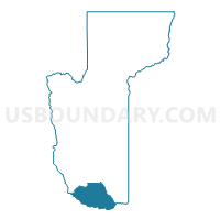
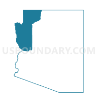
Sara Voting District, Mohave County, Arizona
About
Outline

Summary
| Unique Area Identifier | 525029 |
| Name | Sara Voting District |
| County | Mohave County |
| State | Arizona |
| Area (square miles) | 706.03 |
| Land Area (square miles) | 697.07 |
| Water Area (square miles) | 8.96 |
| % of Land Area | 98.73 |
| % of Water Area | 1.27 |
| Latitude of the Internal Point | 34.39487510 |
| Longtitude of the Internal Point | -113.96003910 |
Maps

Graphs
Select a template below for downloading or customizing gragh for Sara Voting District, Mohave County, Arizona


Neighbors
Neighoring Voting District (by Name) Neighboring Voting District on the Map
- Voting District 11255, San Bernardino County, CA
- Alamo Voting District, La Paz County, AZ
- Chesapeake Voting District, Mohave County, AZ
- Crossman Voting District, Mohave County, AZ
- Oro Grande Voting District, Mohave County, AZ
- Roadrunner Voting District, Mohave County, AZ
- Thunderbolt Voting District, Mohave County, AZ
- Upriver Voting District, La Paz County, AZ
- Vicksburg Voting District, La Paz County, AZ
- Wikieup Voting District, Mohave County, AZ
- Yucca Voting District, Mohave County, AZ
Top 10 Neighboring County Subdivision (by Population) Neighboring County Subdivision on the Map
- Lake Havasu City CCD, Mohave County, AZ (57,129)
- Parker CCD, La Paz County, AZ (20,489)
- Needles CCD, San Bernardino County, CA (7,006)
Top 10 Neighboring Place (by Population) Neighboring Place on the Map
Top 10 Neighboring Elementary School District (by Population) Neighboring Elementary School District on the Map
- Wenden Elementary District, AZ (815)
- Yucca Elementary District, AZ (686)
- Owens-Whitney Elementary District, AZ (610)
Top 10 Neighboring Secondary School District (by Population) Neighboring Secondary School District on the Map
Top 10 Neighboring Unified School District (by Population) Neighboring Unified School District on the Map
- Lake Havasu Unified District, AZ (55,531)
- Parker Unified School District, AZ (9,568)
- Needles Unified School District, CA (7,087)
Top 10 Neighboring State Legislative District Lower Chamber (by Population) Neighboring State Legislative District Lower Chamber on the Map
Top 10 Neighboring State Legislative District Upper Chamber (by Population) Neighboring State Legislative District Upper Chamber on the Map
Top 10 Neighboring 111th Congressional District (by Population) Neighboring 111th Congressional District on the Map
- Congressional District 2, AZ (972,839)
- Congressional District 7, AZ (855,769)
- Congressional District 41, CA (797,133)
Top 10 Neighboring Census Tract (by Population) Neighboring Census Tract on the Map
- Census Tract 9548, Mohave County, AZ (7,012)
- Census Tract 9528, Mohave County, AZ (6,289)
- Census Tract 9533, Mohave County, AZ (6,256)
- Census Tract 9534.02, Mohave County, AZ (5,621)
- Census Tract 9534.01, Mohave County, AZ (5,427)
- Census Tract 201, La Paz County, AZ (2,815)
- Census Tract 9532, Mohave County, AZ (2,657)
- Census Tract 9524, Mohave County, AZ (2,619)
- Census Tract 251, San Bernardino County, CA (1,688)
- Census Tract 202.02, La Paz County, AZ (647)
Top 10 Neighboring 5-Digit ZIP Code Tabulation Area (by Population) Neighboring 5-Digit ZIP Code Tabulation Area on the Map
- 86406, AZ (23,763)
- 86404, AZ (16,243)
- 86403, AZ (15,802)
- 85344, AZ (9,147)
- 92363, CA (5,321)
- 85325, AZ (1,212)
- 86438, AZ (913)
- 85357, AZ (761)
- 85360, AZ (222)